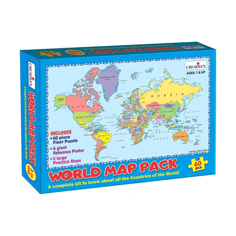
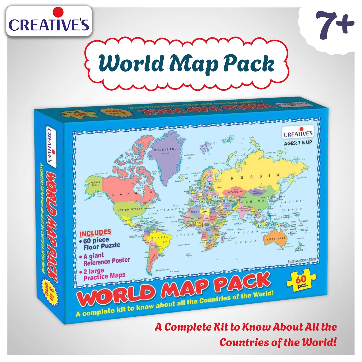
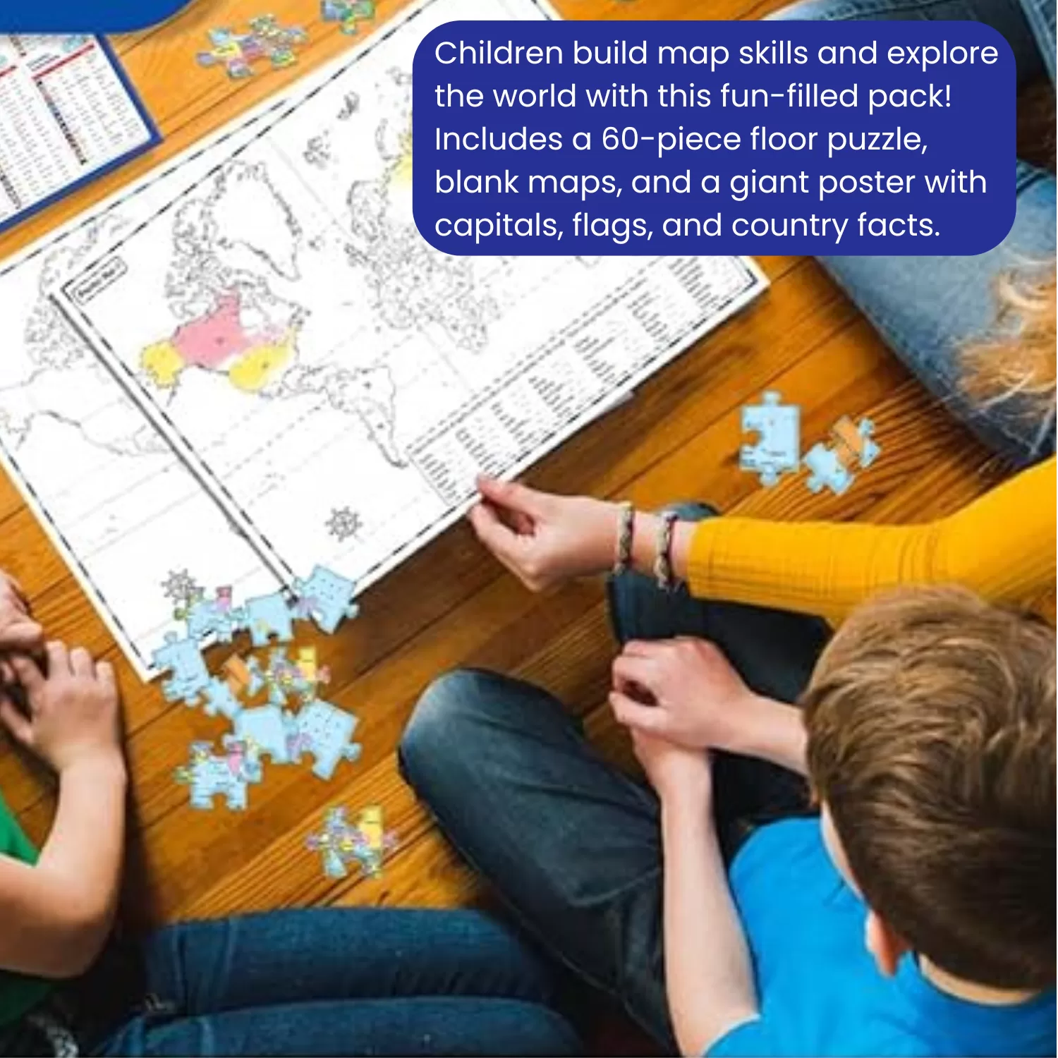
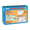
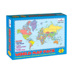
Creative’s World Map Pack is a 3-in-1 geography kit for children aged 7 and up — a 60-piece floor puzzle, 2 fill-in practice maps, and a giant reference poster showing every country’s capital, currency, languages, and flag. Used at home and in primary geography classrooms, it builds world map knowledge, capital city recall, and country identification skills.
About This Product
WORLD MAP FLOOR PUZZLE — 60 LARGE PIECES, 470MM × 350MM, AGES 7+ — A 60-piece floor puzzle of the complete world map builds concentration and spatial geography understanding while children assemble all countries and continents.
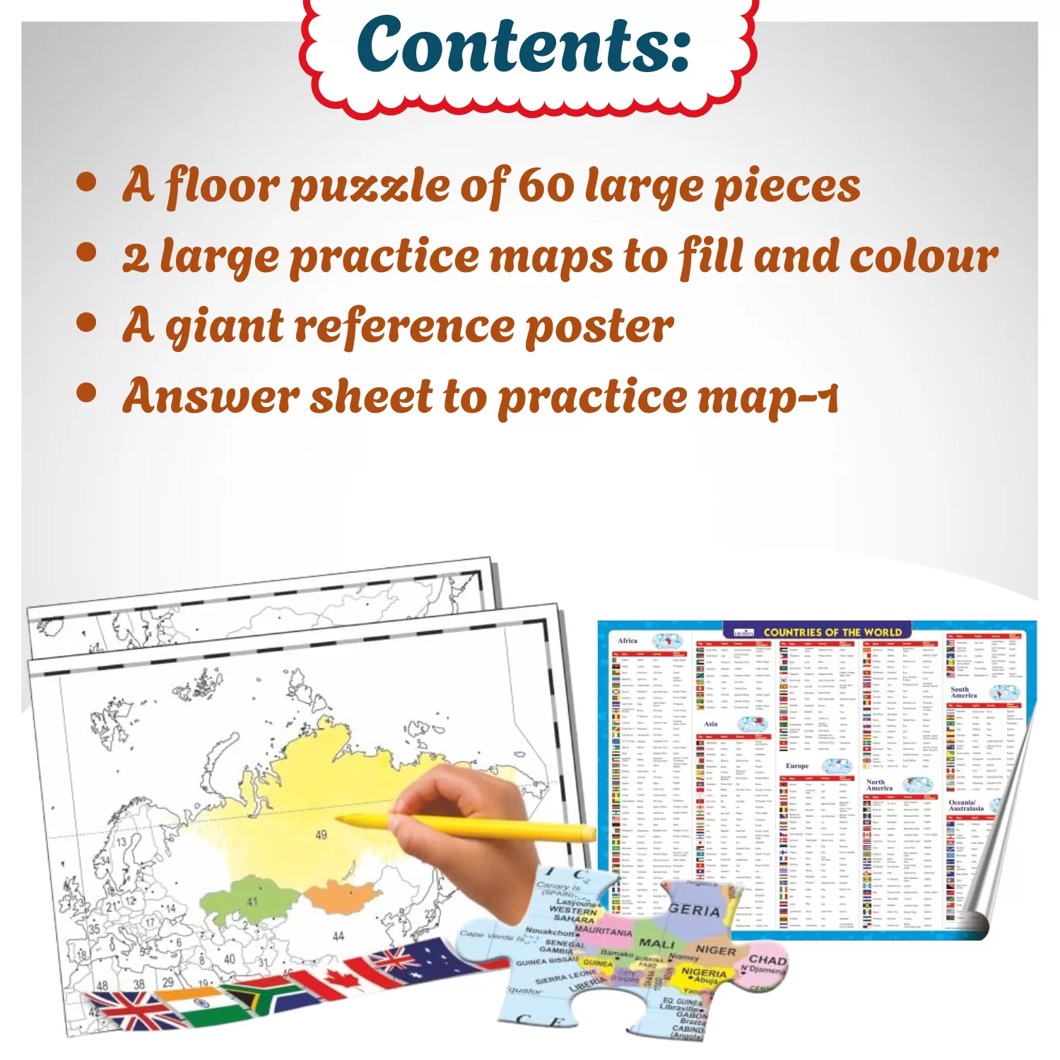
2 FILL-IN PRACTICE MAPS WITH ANSWER SHEET — TEST YOUR KNOWLEDGE — Two puzzle-sized practice maps let children fill in country names and capitals independently or using the puzzle as a guide — with an answer sheet included for Practice Map-1.
GIANT REFERENCE POSTER — COUNTRIES, CAPITALS, CURRENCY, FLAGS, LANGUAGES — The included reference poster covers every country’s capital city, currency, official languages, and flag — a complete world geography reference for the classroom wall.
3-IN-1 GEOGRAPHY KIT — HOME STUDY, CLASSROOM & FAMILY ACTIVITY — Puzzle, practice maps and reference poster together build map reading, location knowledge, and world geography confidence across multiple sessions and skill levels.
Creative's World Map Pack is a 3-in-1 geography kit for children aged
7 and up. The 60-piece floor puzzle (470mm × 350mm, large pieces)
builds the complete world map and gives children a physical understanding
of where every country and continent sits. Two puzzle-sized practice
maps let children test themselves filling in country names and
capitals independently, with the puzzle as a guide or without it and an
answer sheet is included for Practice Map-1.
The giant reference poster completes the kit with a full country-by-country
table: capital city, currency, official languages, and flag for every country in
the world. It works as a classroom display, a homework reference, and a
starting point for every geography question a child asks over the next
several years.
Geography teachers use this pack for map skills and capitals units.
Parents choose it because it is the closest thing to a complete world
geography self-study kit in a single box and children return to it
long after the puzzle is first assembled.
HOW CHILDREN LEARN
Assembling the 60-piece floor puzzle requires children to locate each
piece by continent, country shape, and colour building spatial
geography reasoning across the entire map rather than memorising
facts in isolation.
Using the completed puzzle as a guide to fill in the practice map means
children check their own knowledge, find gaps, and try again self-directed
learning that is more effective than reading a textbook page.
The second practice map done without the puzzle nearby tests recall
under realistic conditions, showing children exactly how much of the
world they now know versus where the gaps remain.
Reading the reference poster to check a capital, currency, or flag turns
a geography question into an active research moment building reference
skill alongside the factual knowledge itself.
A child who has assembled the world map puzzle once has a physical
memory of where each country sits relative to its neighbours a geographical
intuition that classroom maps and screens rarely build as effectively.
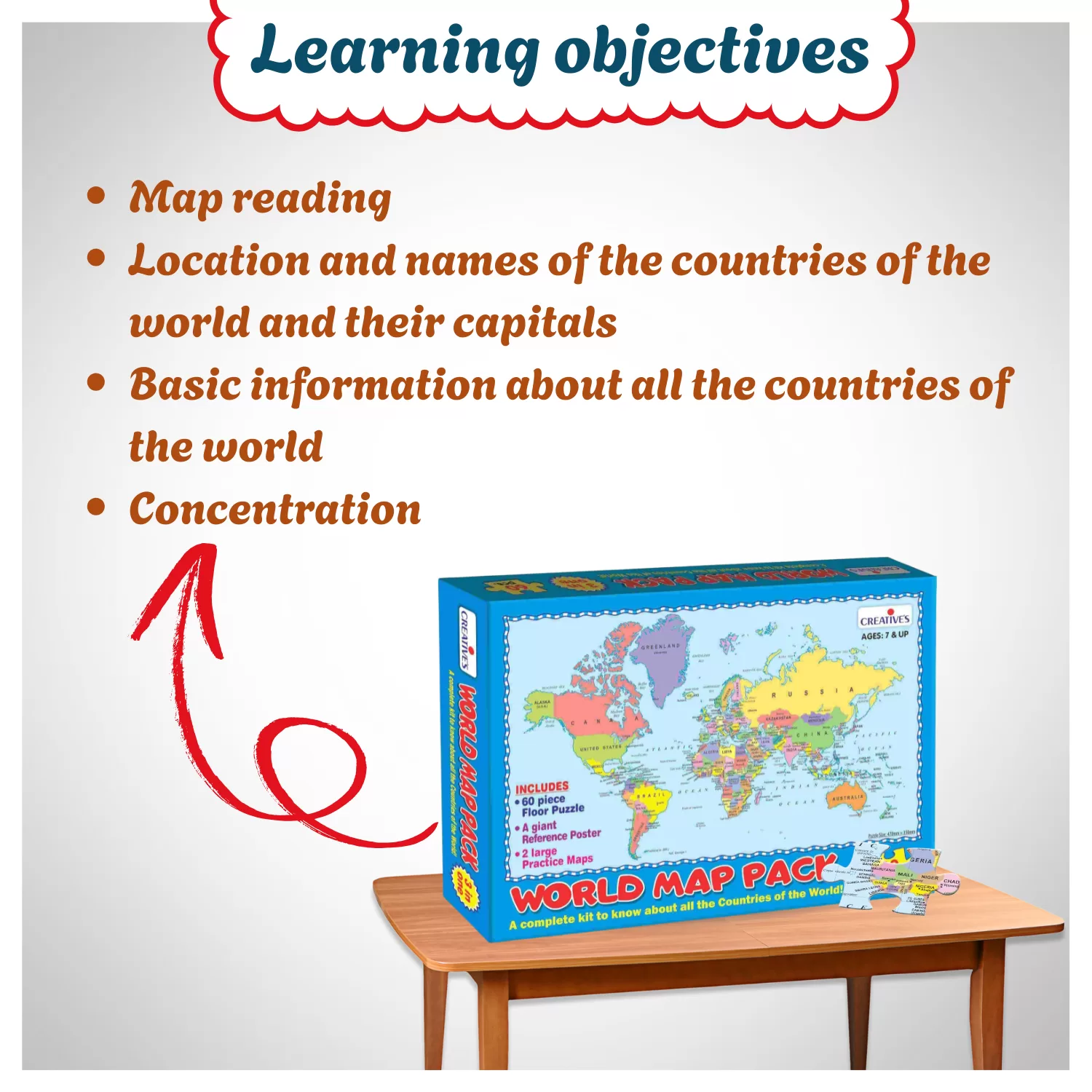
SKILLS DEVELOPED
Map Reading Country & Capital Knowledge Concentration & Focus Spatial Reasoning World Geography Vocabulary Reference Skills Global Cultural Awareness Self-Directed Learning
WHO IS IT FOR
Children aged 7 and up beginning to study world geography, countries,
capitals, and map reading through hands-on activity.
Parents looking for a comprehensive geography activity set that covers
puzzle building, knowledge testing, and world reference in one purchase.
Primary and middle school geography teachers who need a map skills
resource that also serves as a classroom reference display.
Homeschooling families covering world geography, capitals, currencies,
and flags as part of a social studies or global citizenship curriculum.
Children preparing for competitive examinations where world geography,
capitals, and countries knowledge is tested.
Geography-enthusiastic families who want a shared floor puzzle activity
that leaves something genuinely useful — the reference poster
on the wall afterwards.
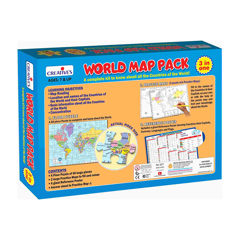
PRODUCT FEATURES TABLE
Age Group: 7 Years and Above Players: Solo or Group Play Type: 3-in-1: Floor Puzzle + Fill-In Practice Maps + Reference Poster Educational Category: Geography, World Map, Countries, Capitals,
Currencies, Flags, Languages Contents: 1 Floor Puzzle (60 large pieces, 470mm × 350mm), 2 Large
Practice Maps (puzzle-size), 1 Giant Reference Poster (Countries, Capitals,
Currency, Languages, Flags), 1 Answer Sheet for Practice Map-1 Safety Certifications: BIS IS 9873 Part 1, EN71 Part 1, 2 & 3, CE Marked
(Not suitable for children under 3 — choking hazard)
Creative’s World Map Pack is a 3-in-1 geography kit for children aged
7 and up. The 60-piece floor puzzle (470mm × 350mm, large pieces)
builds the complete world map and gives children a physical understanding
of where every country and continent sits. Two puzzle-sized practice
maps let children test themselves filling in country names and
capitals independently, with the puzzle as a guide or without it and an
answer sheet is included for Practice Map-1.
The giant reference poster completes the kit with a full country-by-country
table: capital city, currency, official languages, and flag for every country in
the world. It works as a classroom display, a homework reference, and a
starting point for every geography question a child asks over the next
several years.
Geography teachers use this pack for map skills and capitals units.
Parents choose it because it is the closest thing to a complete world
geography self-study kit in a single box and children return to it
long after the puzzle is first assembled.
HOW CHILDREN LEARN
Assembling the 60-piece floor puzzle requires children to locate each
piece by continent, country shape, and colour building spatial
geography reasoning across the entire map rather than memorising
facts in isolation.
Using the completed puzzle as a guide to fill in the practice map means
children check their own knowledge, find gaps, and try again self-directed
learning that is more effective than reading a textbook page.
The second practice map done without the puzzle nearby tests recall
under realistic conditions, showing children exactly how much of the
world they now know versus where the gaps remain.
Reading the reference poster to check a capital, currency, or flag turns
a geography question into an active research moment building reference
skill alongside the factual knowledge itself.
A child who has assembled the world map puzzle once has a physical
memory of where each country sits relative to its neighbours a geographical
intuition that classroom maps and screens rarely build as effectively.
SKILLS DEVELOPED
Map Reading Country & Capital Knowledge Concentration & Focus Spatial Reasoning World Geography Vocabulary Reference Skills Global Cultural Awareness Self-Directed Learning
WHO IS IT FOR
Children aged 7 and up beginning to study world geography, countries,
capitals, and map reading through hands-on activity.
Parents looking for a comprehensive geography activity set that covers
puzzle building, knowledge testing, and world reference in one purchase.
Primary and middle school geography teachers who need a map skills
resource that also serves as a classroom reference display.
Homeschooling families covering world geography, capitals, currencies,
and flags as part of a social studies or global citizenship curriculum.
Children preparing for competitive examinations where world geography,
capitals, and countries knowledge is tested.
Geography-enthusiastic families who want a shared floor puzzle activity
that leaves something genuinely useful — the reference poster
on the wall afterwards.
PRODUCT FEATURES TABLE
Age Group: 7 Years and Above Players: Solo or Group Play Type: 3-in-1: Floor Puzzle + Fill-In Practice Maps + Reference Poster Educational Category: Geography, World Map, Countries, Capitals,
Currencies, Flags, Languages Contents: 1 Floor Puzzle (60 large pieces, 470mm × 350mm), 2 Large
Practice Maps (puzzle-size), 1 Giant Reference Poster (Countries, Capitals,
Currency, Languages, Flags), 1 Answer Sheet for Practice Map-1 Safety Certifications: BIS IS 9873 Part 1, EN71 Part 1, 2 & 3, CE Marked
(Not suitable for children under 3 — choking hazard)